Missions & Sensors
Projects
NDMC
AlpEnDAC
BioCliS
LISA
AlpAirEO
WMO-GAW Aerosol
DLR internal services
Trace Gas Dashboard
Dynamics Dashboard
About WDC
Contact
Imprint
Terms of Use
Barrierefreiheit
Accessibility Statement
Datenschutzerklärung
Privacy Policy
WDC Home
Local Weather
Oberpfaffenhofen
|
|
 |
AATSR-DV
The AATSR-Dual View (DV) algorithm uses the atmospheric reflectance at TOA measured by AATSR at two viewing angles, to eliminate the effect of the surface reflectance on the reflectance measured at the top of the atmosphere (TOA). The path reflectance is retained and used with the calculated reflection at TOA due to a mixture of aerosol models to retrieve the AOD. A large number of aerosol mixtures are used to obtain the most appropriate aerosol mixture based on error minimization using all suitable wavelengths. To account for interactions, the TOA reflection is calculated including molecular effects. The final result is the AOD at 0.55, 0.67 and 1.6Ám over land; over ocean the AOD at 0.55, 0.67, 0.86 and 1.6Ám is retrieved using a single view. The retrieval is currently done on either individual pixels or for 10x10 pixels.
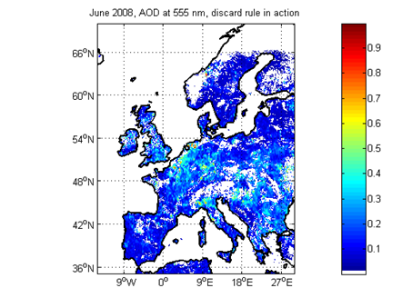
Example result / latest result (if near-real time) |
 |
| Satellite: | ENVISAT (ESA) |
| Instrument(s): | AATSR |
| Algorithm PI: | Gerrit de Leeuw |
| Algorithm Development: | Pekka Kolmonen |
| Contact details: | gerrit.leeuw@fmi.fi |
| Parameter(s): | over land: spectral AOD at 0.55, 0.67 and 1.6Ám, Over ocean: spectral AOD at 0.55, 0.67, 0.86 and 1.6Ám ┼ngstr÷m exponent; aerosol mixture optional |
| Aerosol algorithm: | AATSR-DV (ADV) over land; AATSR-SV (ASV) over ocean |
| Cloud screening: | ADV and ASV have their own cloud screening |
| Aerosol model: | AERONET derived aerosol models (Dubovik, 2002; Levy 2007): variable mixture of fine and coarse mode |
| Retrieval assumptions: | Mie scattering on spherical particles, Lambertian surface reflection, ratio between nadir and forward views independent of wavelength |
| Retrieval limitations: | surface reflectance << 1, no application to the 0.87Ám channel over land due to the strong reflection by vegetation, different algorithms over land and ocean |
| Spatial, temporal coverage: | 2003-present / global under development |
| Spatial, temporal resolution: | 0.1o x0.1o / 512km swath / 5 days repeat cycle |
| Operations status: | scientific |
| Validation status: | intercomparison with groud-based and MODIS observations |
| Quality control: | major elements |
| last algorithm version: | 0.9/ADV(02/2010) |
| last validation: | 02/2010 (on-going) |
Algorithm
description |
Product
format description |
|
Version
explanation |
Validation
summary |
|
