Missions & Sensors
Projects
NDMC
AlpEnDAC
BioCliS
LISA
AlpAirEO
WMO-GAW Aerosol
DLR internal services
Trace Gas Dashboard
Dynamics Dashboard
About WDC
Contact
Imprint
Terms of Use
Barrierefreiheit
Accessibility Statement
Datenschutzerklärung
Privacy Policy
WDC Home
Local Weather
Oberpfaffenhofen
|
|
|
|
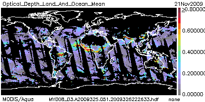
MODIS Collection 5
The MODIS Aerosol Product monitors the ambient aerosol optical thickness over the oceans globally and over a portion of the continents. The additional Deep Blue product fills in some of the missing continental areas in Collection 5.1. Further, the aerosol size distribution is derived over the oceans. Daily Level 2 data are produced at the spatial resolution of a 10�10 1-km (at nadir)-pixel array. There are two MODIS Aerosol data product files: MOD04_L2, containing data collected from the Terra platform; and MYD04_L2, containing data collected from the Aqua platform.
Example result / latest result (if near-real time) |
 |
| Satellite: | EOS Terra / EOS Aqua |
| Instrument(s): | MODIS |
| Instrument/algorithm PI: | Lorraine Remer, NASA |
| Contact details: | lorraine.a.remer[at]nasa.gov |
| Parameter(s): | AOD, �ngstr�m exponent, fine mode ratio (over ocean) |
| Aerosol algorithm: | MOD04_L2 |
| Cloud screening: | internal cloud mask |
| Aerosol model: | from AERONET |
| Retrieval assumptions: | bimodal aerosol model from one fine mode and one coarse mode |
| Retrieval limitations: | different retrievals over land and ocean, no retrieval over bright surfaces except for Deep Blue |
| Spatial, temporal coverage: | 2000-present / NRT, global |
| Spatial, temporal resolution: | 1km / 2330km swath / 16 days repeat cycle |
| Operations status: | operational / reprocessing |
| Validation status: | 2000-present online access to validation results |
| Quality control: | pixel-wise quality flag |
| last algorithm version: | collection 5 (04/2006) / collection 5.1 (05/2008) |
| last validation: | 2000-present |